This sector includes the largest number of organizations using open data. These organizations provide data infrastructure, software applications, data analytics and visualizations for a wide range of users. The most used types of data include geospatial, environmental, and demographic and social.
Several organizations help provide easier access to data, often to higher quality data providing platforms, APIs, and technology infrastructure to help government agencies provide their data. Others develop software and mobile applications to help users access data, and often improve the data in the process. A large number of organizations also provide data analytics and visualizations that make it easier not only to access the data but to interpret it. These have applications in a wide range of fields including medicine, transportation, finance, energy, and agriculture.
Open geographical and satellite data helps strategists both in and outside of government for land and resource management and planning. Much data analysis and visualization uses geospatial and mapping data to provide geospatial intelligence, and many organizations focus exclusively on this type of data. These focus on identifying geographical patterns, providing map-based interfaces for their customers, and predictive modelling.
Types of Data Most Used
Size, Type & Founding Year
How Organizations Use Open Data

Use Cases

Template
Country: United States
Impact: Farmers benefit from tools for better crop management and to measure environmental factors
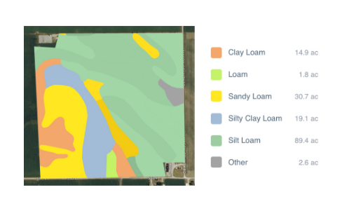
Data Used: Rainfall data from US National Oceanic and Atmospheric Administration’s (NOAA) National Climatic Data Center, soil data from US Department of Agriculture
FarmLogs provides farmers with a free software and mobile application to map and analyze crop yields and environmental conditions for crop growth through government data. Their Farmlogs free Standard includes several features: Field Mapping, Scouting and Notes, Activity Tracking, Rainfall Tracking, GDD Accumulation, Soil Composition Maps, Growth Stage Analysis, Yield Maps, Input Planning. They also empower farmers to coordinate with the government to request data for their lands. On their website, FarmLogs details instructions on how to contact the US Department of Agriculture's Farm Service Agency for field boundary data. Upon receipt, FarmLogs interprets the data and creates field boundaries on mapping systems for farmers to demarcate their lands.