Open data is being used in this sector to guide investments and trading, increase access to capital and insurance, and evaluate risk. The most used data includes financial, business, and economic information, as well as demographic and social data.
Open data is being used as a resource to increase access to banking and finance around the globe. In a number of countries, organizations are using open data to increase financial access and inclusion for “high-risk” customers who otherwise might have no access to capital. They use demographic and social, economic, labor and other data sources to evaluate loans for citizens and organizations with no or limited credit history. Similarly, others use business registries in combination with other kinds of data to evaluate new, small businesses seeking financing. Since lenders often can’t afford to do the due diligence needed to lend to these businesses, open data is being used to help evaluate the credit risks they may pose.
The insurance industry has long been reliant on public data. For instance, the probabilities and frequencies of traffic accidents or diseases need to be predicted for reasonable valuation, and open government data is critical in this regard.
Open data also helps guide investments for economic as well as social benefit. Economic statistics are a bedrock of financial analysis, and many organizations also rely on company registers, consumer price indices, satellite imagery, and sector-specific government data to inform their investments in companies, real estate, currencies, commodities, and other assets.
Types of Data Most Used
Size, Type & Founding Year
How Organizations Use Open Data

Use Cases


Template
Country: United States
Impact: Farmers benefit from tools for better crop management and to measure environmental factors
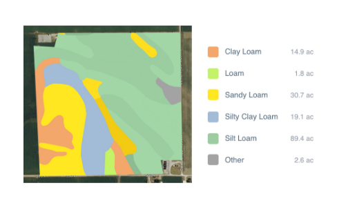
Data Used: Rainfall data from US National Oceanic and Atmospheric Administration’s (NOAA) National Climatic Data Center, soil data from US Department of Agriculture
FarmLogs provides farmers with a free software and mobile application to map and analyze crop yields and environmental conditions for crop growth through government data. Their Farmlogs free Standard includes several features: Field Mapping, Scouting and Notes, Activity Tracking, Rainfall Tracking, GDD Accumulation, Soil Composition Maps, Growth Stage Analysis, Yield Maps, Input Planning. They also empower farmers to coordinate with the government to request data for their lands. On their website, FarmLogs details instructions on how to contact the US Department of Agriculture's Farm Service Agency for field boundary data. Upon receipt, FarmLogs interprets the data and creates field boundaries on mapping systems for farmers to demarcate their lands.


