North America has more examples of organizations using open data than any other region in the world. In the U.S. and in Canada, open data is used across all sectors of the economy and throughout the countries.
North America has a large number of for-profit organizations that use open data. The highest use is seen in the IT and geospatial, business, research and consulting, and governance sectors, in comparable amounts by new as well established organizations.
This region includes the greatest proportion of large companies (200+ employees) that use open data for their products and services, such as Building Eye, Climate Corporation, the Weather Company, and Zillow. It also includes more organizations using open data for research than other regions. The most used types of data across the region include geospatial, demographic and social, health and legal.
Size, Type & Founding Year
Sectors Using Open Data

Use Cases

Template
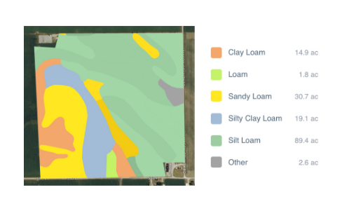
Country: United States
Impact: Farmers benefit from tools for better crop management and to measure environmental factors
Data Used: Rainfall data from US National Oceanic and Atmospheric Administration’s (NOAA) National Climatic Data Center, soil data from US Department of Agriculture
FarmLogs provides farmers with a free software and mobile application to map and analyze crop yields and environmental conditions for crop growth through government data. Their Farmlogs free Standard includes several features: Field Mapping, Scouting and Notes, Activity Tracking, Rainfall Tracking, GDD Accumulation, Soil Composition Maps, Growth Stage Analysis, Yield Maps, Input Planning. They also empower farmers to coordinate with the government to request data for their lands. On their website, FarmLogs details instructions on how to contact the US Department of Agriculture's Farm Service Agency for field boundary data. Upon receipt, FarmLogs interprets the data and creates field boundaries on mapping systems for farmers to demarcate their lands.