Organizations in this region are using open data in all economic sectors. The majority of organizations are for profit, and located in higher income countries. Over three-quarters are small-to-medium enterprises (SMEs) of 200 employees or less.
The sectors with the most organizations using open data in East Asia and the Pacific are the IT and geospatial, business, research and consulting, and energy and climate sectors. The most used types of information include open geospatial, environmental, demographic and social, transportation, and economic data and statistics.
Overall, many organizations in the region are following a commercial model: Nearly three-quarters are for-profit companies. The majority of these are located in higher income countries (Australia, Japan, Korea, New Zealand, and Taiwan). In low to lower middle income countries in this region (Philippines, Indonesia, Papua New Guinea, Cambodia) open data is used primarily by nonprofits for more transparent and inclusive governance. In China, the examples consist mainly of academic institutions and developer groups using environmental data for research and visualizations.
Size, Type & Founding Year
Sectors Using Open Data

Use Cases

Template
Country: United States
Impact: Farmers benefit from tools for better crop management and to measure environmental factors
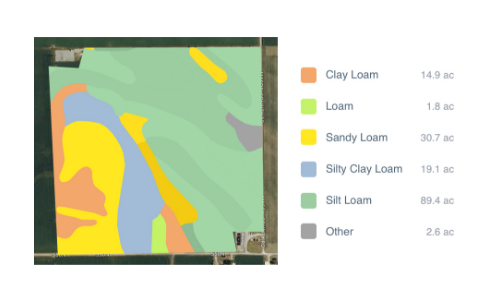
Data Used: Rainfall data from US National Oceanic and Atmospheric Administration’s (NOAA) National Climatic Data Center, soil data from US Department of Agriculture
FarmLogs provides farmers with a free software and mobile application to map and analyze crop yields and environmental conditions for crop growth through government data. Their Farmlogs free Standard includes several features: Field Mapping, Scouting and Notes, Activity Tracking, Rainfall Tracking, GDD Accumulation, Soil Composition Maps, Growth Stage Analysis, Yield Maps, Input Planning. They also empower farmers to coordinate with the government to request data for their lands. On their website, FarmLogs details instructions on how to contact the US Department of Agriculture's Farm Service Agency for field boundary data. Upon receipt, FarmLogs interprets the data and creates field boundaries on mapping systems for farmers to demarcate their lands.